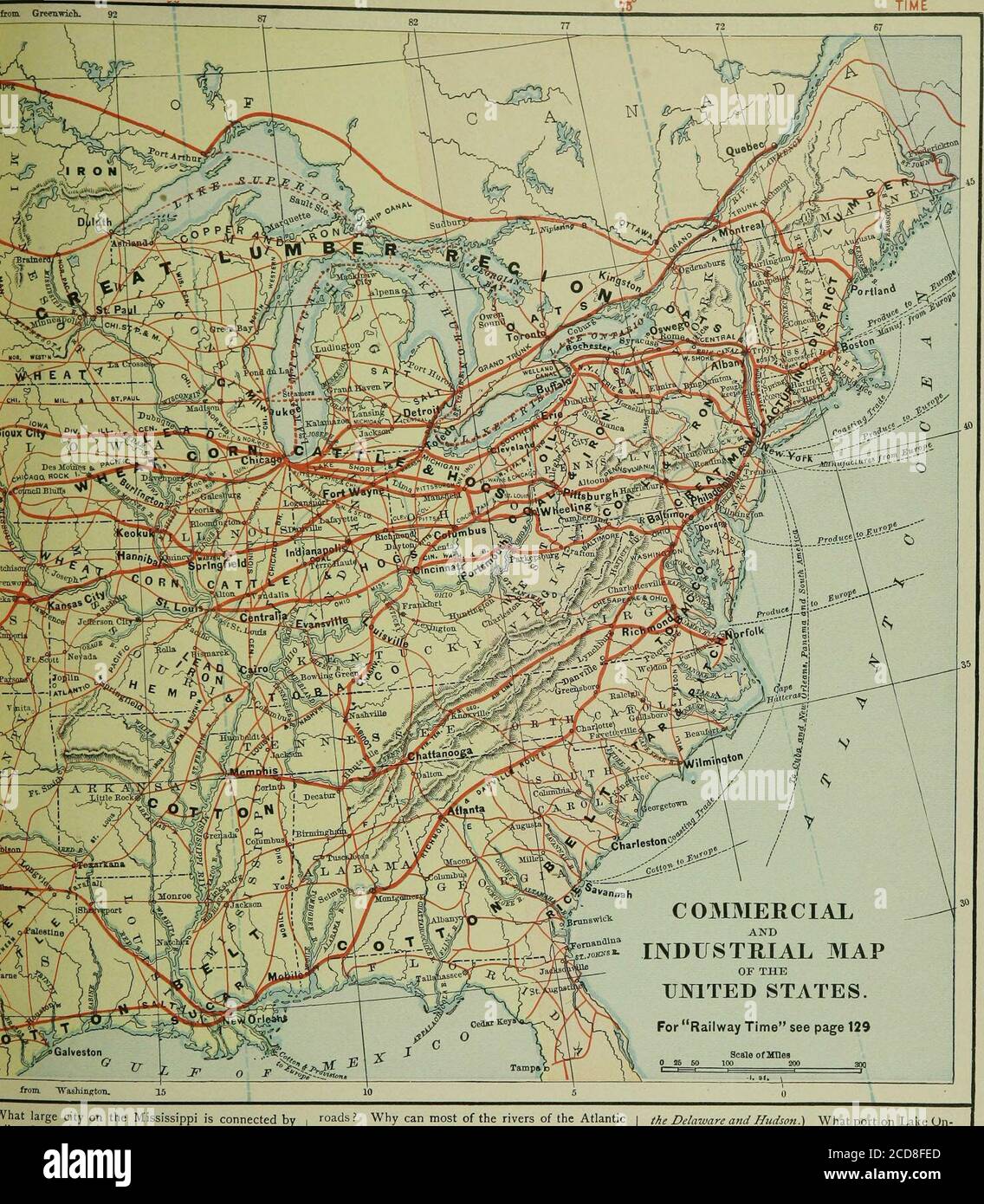
. La geografia della scuola di Harper. Vada a Pittsburgh passa attraverso FortWayne? Di che strada della Pennsylvania è una continuazione? Che strada da Chicago passa attraverso Wheel-ing a Baltimora? Che strada da Pittsburgh attraversa Columbus e Indianapolis a St. Louis?a che altro porto sull'Ohio ha una diramazione da Columbus? Che strada da Toledo pa.ises attraverso Springfield. Illinois, A quali due città del tsisippi ? Quale strada corre a nord dal Cairo? si forchetta? In quale città la cisterna brterminerà? Il ramo occidentale? Che strada St. Louis con Chicago? Con IndianapolisPittsburgh
1478 x 1691 px | 25 x 28,6 cm | 9,9 x 11,3 inches | 150dpi
Altre informazioni:
Questa foto è un'immagine di pubblico dominio, il che significa che il copyright è scaduto o che il titolare del copyright ha rinunciato a tale diritto. Alamy addebita un costo per l'accesso alla copia ad alta risoluzione dell'immagine.
Questa immagine potrebbe avere delle imperfezioni perché è storica o di reportage.
. Harper's school geography . go to Pittsburgh passes through FortWayne ? Of what Pennsylvania road is it a continua-tion ? What road from Chicago passes through Wheel-ing to Baltimore ? What road from Pittsburgh runsthrough Columbus and Indianapolis to St. Louis?To what other port on the Ohio has it a branch fromColumbus? What road from Toledo pa.ises through Springfield. Illinois ? To what two cities on tsissippi ? What road runs north from Cairo? does it fork? In what city does the cistern brterminate? The western branch? What roadnects St. Louis with Chicago ? With IndianapolisPittsburgh? With Cincinnati ? What road connects Chicago with Omaha!what more western road docs it connect ? Whatcontinues the Iniou Pacific from Ogden to SanlCisco? What road extends east from Denverwhat city does a branch from IVnvcr join the 1Iacific ? What city on the Missouri at the casterof the Kansas Pacific? What road connects KCity with Pcming ? Pcming with San Ftaiv (>rrKf>u, is$>i>tB EASTERN TIME INTERCOLONIALTIME. Vhat large city on the Mississippi is connected bylilroad with Kansas City? What road runs south-est from St. Louis ? To what gulf-port does it formart of a line? What other road forms part of a lineom St. Louis and Cairo to Galveston? Throughhat states does this line run ? What road runs south from Richmond ? To what5rt? Between Richmond and Atlanta? Norfolkid Chattanooga? Louisville and Memphis? Louis-He and Mobile ? Cairo and New Orleans ? Mobileid Cairo ? Memphis and Charleston ? What color on this map shows how far a river is?vigable ? In which half of the United States arearly all the navigable ri-ers ? Most of the rail- roads ? Why can most of the rivers of the Atlanticcoast be ascended only a short distance ? In whatpart of the United States are the longest navigablerivers ? Name the chief navigable rivers of the NorthAtlantic States. Of the Middle Atlantic. The SouthAtlantic. The South Central. The North Central.The West Central. What rivers of t